Getting Here
The road is closed. Winter access is by ski or splitboard only — that's the point.
On Ophir Pass, between two towns
The OPUS Hut sits just below the top of Ophir Pass at 11,765 feet, roughly halfway between Silverton (via US-550) and the town of Ophir on the Telluride side. Whichever side you come from, you're crossing one of the great high passes of the San Juans to get here.
Winter Access
You are responsible for making your own determinations of what is safe to travel in the backcountry. Skiing and wilderness travel in the San Juan Mountains have inherent risks, hazards and dangers that cannot be eliminated; they are very real and not to be taken lightly. People have died or been seriously injured traveling and recreating in this area.
Both winter approaches to the Opus Hut traverse through potential avalanche terrain, and there is no route which avoids avalanche terrain entirely. Please make sure you are comfortable traveling in these kinds of conditions, have the appropriate backcountry ski experience, and are properly equipped with avalanche safety and rescue equipment (at minimum, a beacon, shovel, and probe, and the knowledge of how to use them).
If you and your group do not have the equipment for and substantial experience with: decision making, and travel in serious avalanche terrain, and the use of navigation skills and tools in difficult conditions, choose another hut system or hire a professional guide. You can find a list of local guides in our Guide Services FAQ.
In the weeks and days leading up to your trip, check the CAIC Northern San Juan zone for current avalanche conditions.
There is no cell phone service for the majority of both approaches. Please make sure your maps are downloaded “offline” beforehand so you can use them to help navigate if needed.
Online Map
Here is a link to an online map showing the routes from Ophir and Highway 550 using CalTopo (a common backcountry mapping application):
Click here to view the interactive winter approach map
The images below are sourced from this map, but the interactive version allows you to zoom and scroll around.
The blue line represents the best winter access to the OPUS Hut, represented by the black hut icon. Slopes shaded red or darker are over 30 degrees in pitch and could possibly avalanche during certain conditions.
Note: These are the most commonly traveled routes during normal conditions. You may need to adjust your route depending on specific avalanche or weather conditions.
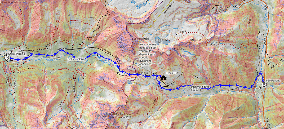
The Ophir Pass road is closed in the winter, and one of the two following approaches is required from either Silverton / Highway 550 or the town of Ophir.
From Silverton – Hwy 550
3.5 miles – 1,700 Vertical feet
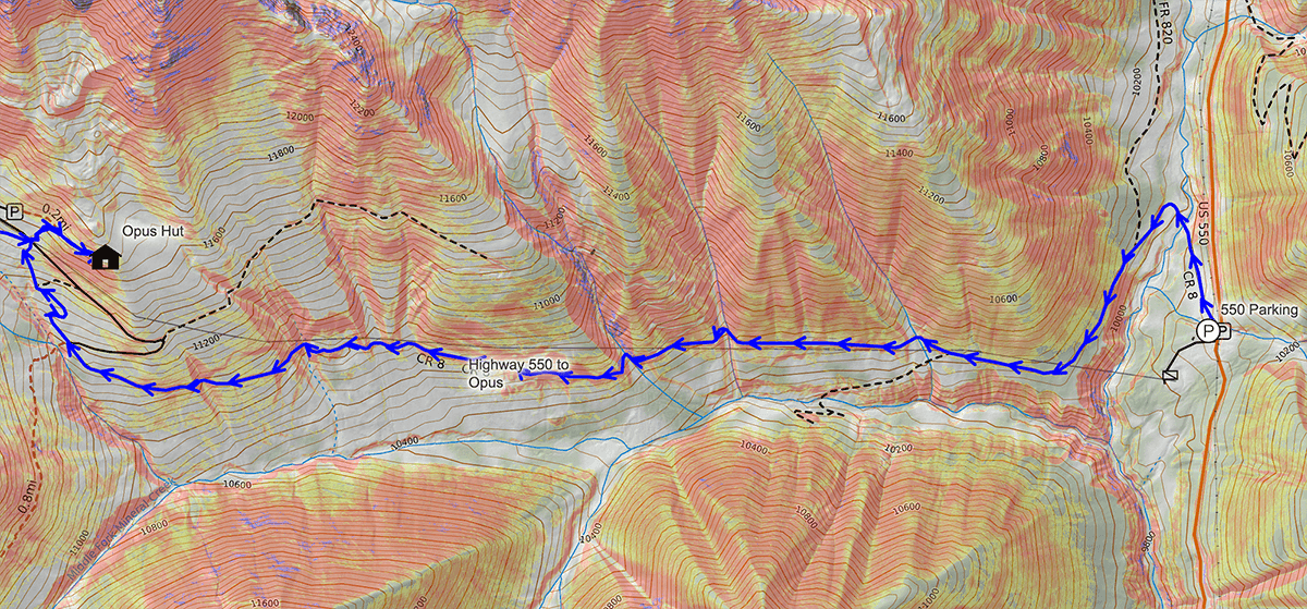
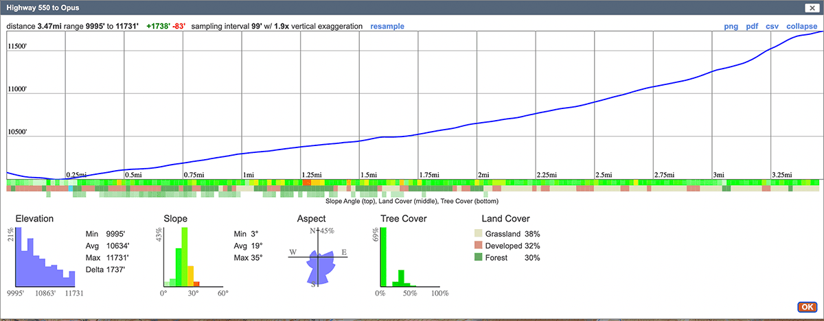
This is the most straightforward route to access the hut, and the route taken by 90% of winter guests.
Parking: The winter trailhead/parking for the OPUS is the summer turnout at the beginning of the Ophir pass road, 5 miles north of Silverton on Hwy 550. Please be sure not to block the access road to the electrical power station. The parking lot is shared with day-use skiers on red mountain pass, please carpool if you can to reduce the number of cars in the lot. If there is snow in the forecast, park near the edges of the lot, if you can, to allow CDOT easier access to plow the lot.
Put on your skis and follow the Ophir pass road (not plowed), to the north, downhill across Mineral Creek on the bridge and swing back south climbing on the road. There is often a skin track heading straight down towards the creek and power station, do not take this.
Climbing along the north side of the creek, the road crosses the run out of two large slide paths, then the ruby creek ravine. Beyond the ravine the trees begin to open up and eventually you come to a large treeless area. This is the run out of several large south facing avalanche paths off the eastern shoulder of Lookout Peak above you to the north.
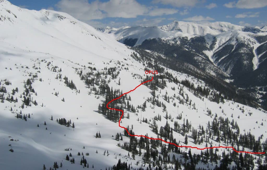
Continue up the Ophir pass road, traversing south facing slopes. You will encounter two gullies crossing the road before the road reaches the first of two switchbacks. Treat these cross loaded gullies with caution; while they are not as big as some of the other slide paths, they do slide from time to time.
Just before entering the trees at the first switchback, look up hill and you will see the hut. Upon reaching the first switch back, leave the main road and continue straight ahead paralleling the creek west towards the pass. The route winds uphill through open trees to the meadow pictured in the photo above. There are blue diamond ski trail markers along the trail to the hut from this point. You briefly head north through the open meadow, crossing the summer road, and then after a few hundred yards, you turn east, and head up through the trees about a quarter mile (200-300 vertical) until you get to the hut.
From Ophir
4.3 Miles – 2,300 Vertical feet
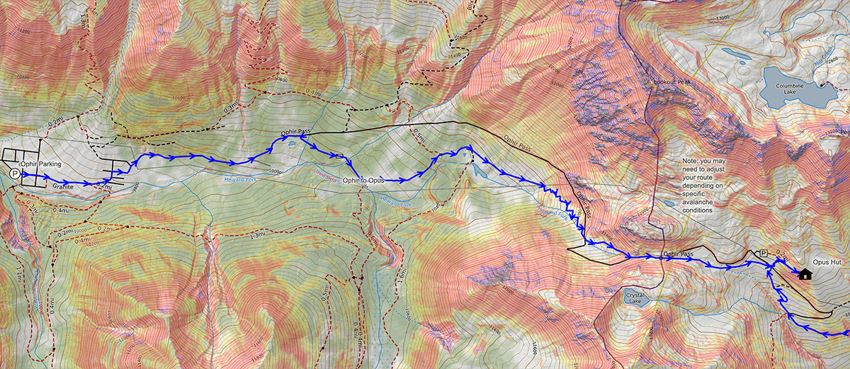
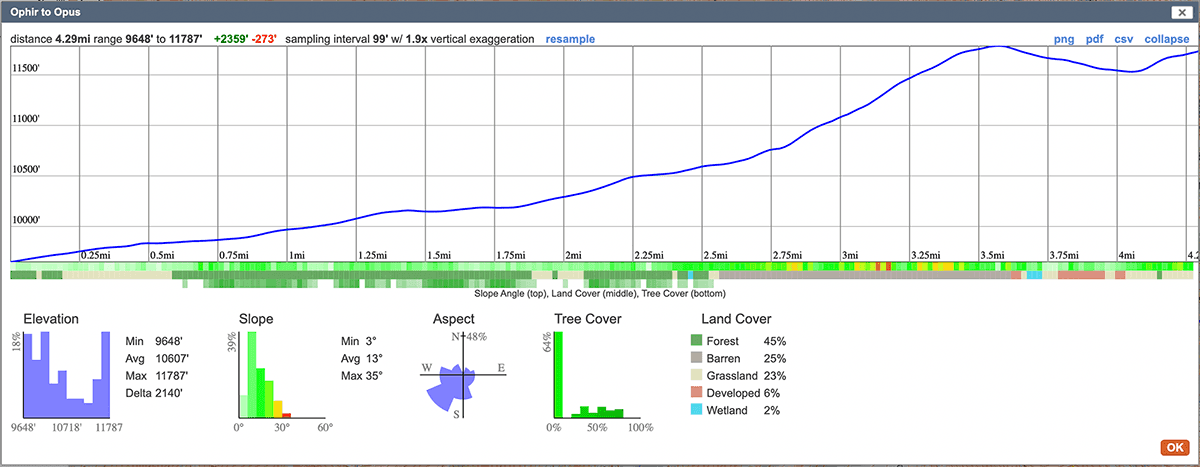
This approach is a little more intimidating and less straight forward than the Hwy 550 approach as you are only on the road for the first 1/3rd of the ski in.
Parking: The overnight parking in Ophir is at the Town Hall/ Maintenance facility, which is in the western portion of the town. When you come into the town of Ophir from the Highway, take the right hand fork in the road. The Town Hall/ Maintenance barn is immediately on your left. Overnight parking is on the right side of the road opposite the maintenance barn. The parking lot is shared with day-use skiers in the Ophir area, please carpool if you can to reduce the number of cars in the lot.
Put on your skis and head east through town on the main road, which is usually snow-covered. You'll cross through an open meadow on the road, before coming to the east half of town. Follow the signs for “Ophir Pass”. Once you're through the east half of town, you'll follow the unplowed road as it heads up the valley.
From the town of Ophir, follow the Ophir Pass road 1/2 mile to the first creek crossing. Stay on the main road, and don't take the first road you see on the right. Continue another 1/4 mile on the road until you cross a slide run-out. After crossing the run out, but before re-entering the trees, you will see a typically well traveled road that heads off to the right. This junction will often be labeled “Iron Spring” on maps and the road you are on is called “Swamp Canyon Road”
Follow this trail for about a half a mile. You will cross another large slide path, and then re-enter the trees. Once you re-emerge from the trees, there will be a big open meadow in front of you, and a typically well-used skin track heading right down across a stream / river. Don't cross the river, instead head east across the open meadow. As you are crossing the meadow, you will cross another slide path before you re-enter the trees.
As you re-enter the trees you should see an opening heading north and east where an old road runs. Following this road will eventually take you through the trees and you'll emerge at some beaver ponds at the end of the valley. From here you can see the valley start to get steeper as it heads up toward the pass.
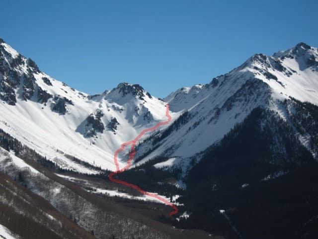
From here you will follow the valley bottom up towards the pass, crossing the run out of many slide paths from north and south facing slopes (pictured below). At this point, you will need to make a decision about which path to take. Typically the route will follow along the bottom of the south facing slopes just above the bottom of the valley. However, if you are concerned about avalanche activity on south facing slopes, you should shift your route down to the valley floor, or even slightly onto the north facing slopes. How to ascend this part of the valley is a judgement call you must make depending on your evaluation of the current conditions, and which aspects you are trying to avoid.
As you ascend up the valley, you will eventually cross the summer road again and find yourself on a bench. From here, you want to stay to the left (north) side of the valley, and ascend on the south facing slopes to the top of the Pass. On a satellite map, this will follow an old “carriage road” from the mining days.
Once you hit the top of the pass, descend to the meadow described in the east side approach above, about a half mile east past the top of the pass. From that meadow, the trail climbs up ENE about 1/4 mile into the trees and across a clearing until you get to the hut.
If you have access questions please email us at info@opushut.com
GPX Routes
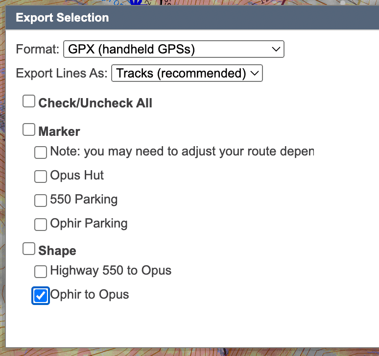
If you would like to download a GPX version of either of the above routes, please go to the CalTopo map [https://caltopo.com/m/6SVP1] and use the “Export” function, which will provide either of the routes in a number of common formats. Please use these routes as a general guide and do not follow them blindly. Conditions in the field may require you to adjust your route for safety or ease of travel.

Before you lose cell service
There is no cell phone service at the hut, and typically not much once you leave Silverton, Ouray, or Telluride. Save your maps, directions, and the emergency numbers from your pre-arrival email before you go:
- Emergency text (in your pre-arrival email) — goes to the owner and the hut hosts working that day.
- Emergency satellite phone at the hut — also in your pre-arrival email.
Please share these with friends and family, and ask them to use them only for real emergencies — not just to check in. For everything else before your trip: info@opushut.com.